
Imaging earthen dams, levees and impoundment structures using non-intrusive methods provides efficient integrity evaluation.
Arm your organization and the public with a more complete picture and understanding of the conditions that inform safety assessment, remediation plans and priorities.
 Risk assessment starts here.

Zonge applies geophysics to the evaluation of embankments across the United States and Canada. Overtopping, liquefaction, collapse, and seepage are worrisome attributes for which geophysical measurements help in prioritizing
and defining mitigation efforts.
Mobile conductivity studies evaluate long levee stretches affordably.
 The Dynamic NanoTEM (DNT) — a Zonge-developed time-domain electromagnetic (TDEM) method and instrument to quickly and effectively map construction materials, geologic under-pinnings, and possible levee seepage locations — is rapidly changing the way engineers are approaching the problem of too many miles, too little time and resources.
The DNT method allows thousands of feet of profiling per day, making it ideally suited for surveying long stretches of levees and for fast, cost-effective dam evaluation. The key advantage is the mobility plus adaptability of the instrument which allows continuous (mobile) data collection while providing operators the ability to adjust parameters to almost any terrain and target information.
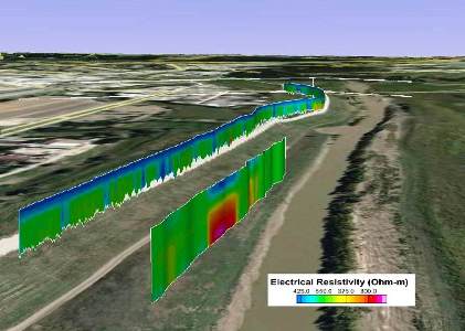
Tomography and IP methods show geologic composition.
Small-strain, elastic constants in and beneath the structure; grain size, saturation, and geologic composition are required for evaluation and redesign. But for obvious reasons, drilling multiple exploratory holes on a dam or levee is not the ideal solution.
Zonge conducts electrical resistivity tomography (ERT) and induced polarization (IP) studies to evaluate saturation and geologic source materials. Although data collection is somewhat slower than with mobile methods, ERT and IP show more detail at greater depth.
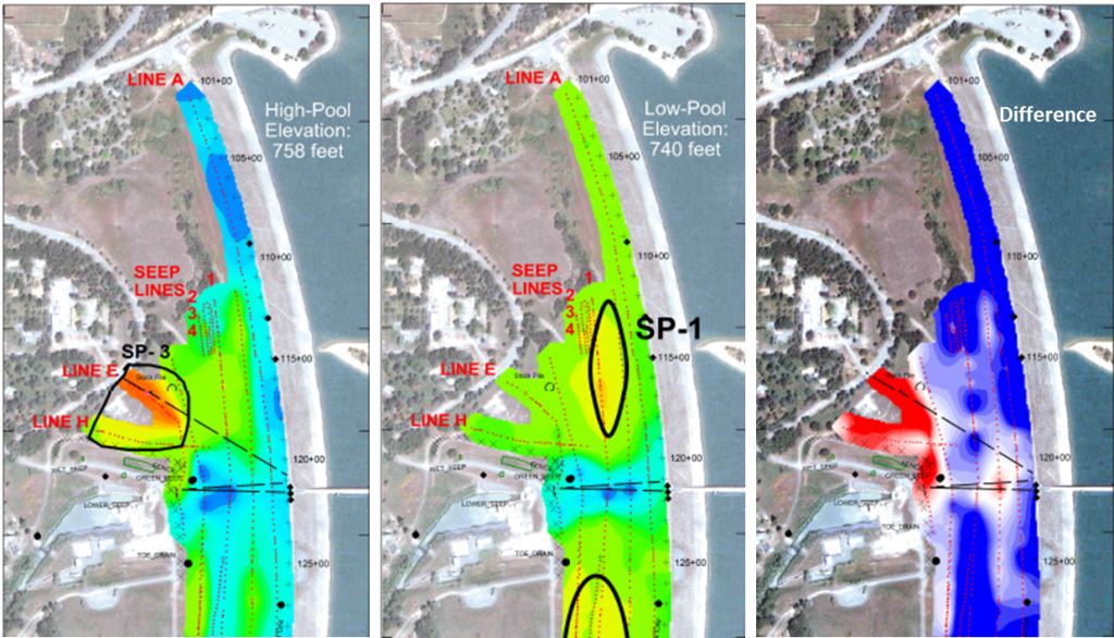
Self-potential data show seepage fluid-flow paths.
A self-potential (SP) geophysical survey measures the voltage difference across the surface of a dam or levee. Underground fluid-flow paths are detected as anomalies in the self-potential field when spurious causes can be eliminated (or at least held constant while varying the head on flow paths), in other words for dams, measured at high and low pool. The result is a clear picture of the location, extent, and type of flow prior to remedial design.
Seismic surveys detect areas
at risk before they surface.

Seismic methods, such as P-wave refraction tomography and multi-channel analysis of surface waves (MASW) are used to map the stiffness of materials in cross-sections on the dam or levee.
Soft spots, that could be at risk of failure, are often detected before there are any surface expressions. Also a critical component of stability calculations is knowing the distribution of the in-situ elastic constants inside the dam, which can be determined using seismic methods.