
Ground Penetrating Radar (GPR) Survey Method
Overview
Ground Penetrating Radar (GPR) is the general term applied to survey methods employing high-frequency electromagnetic waves to map below-ground lithology or buried objects. GPR methods are both high-resolution and highly site specific, which means they can produce excellent results but only in specific conditions.
Zonge has completed radar surveys of objects at depths from 2 inches to 20 feet under the right conditions. A variety of modern computer-driven instruments are used depending on the project.
Advantages and limitations
Ground Penetrating Radar is among the high-resolution geophysical techniques available for shallow engineering and environmental projects. As such, GPR profiles are spectacularly revealing when successful (i.e. detection of plastic gas pipes in sandy soil, shallow lithology, and buried drums).
However, GPR is not recommended in many areas. High attenuation in conductive soils renders GPR impractical in these areas; so any geologic setting where the near-surface is dominated by heavy clay soils would be a poor environment for GPR use. This unpredictable performance usually requires a test phase over a known situation.
Geologic model
The geologic model underlying GPR is a layered subsurface with changes in the electrical properties (specifically the dielectric constant) at material boundaries. The layers are considered homogeneous but have non-planar boundaries. Manmade objects exhibit a strong contrast with most earth materials and can usually be detected.
How it works
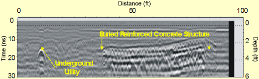
A GPR survey involves using a specialized antenna to focus electromagnetic pulses (radar signals) of short duration into the ground. These signals propagate and are then reflected by discontinuities or interfaces in soil materials and return to be detected by a receiver antenna. more
The reflected signals are processed and displayed on a graphic recorder. The time axis is converted to depth by an estimated velocity function. As the antenna is moved along the surface, this display results in a cross-section record of distance traveled vs. depth (time) of the reflected radar signatures.
Logistics
Balancing resolution with depth requirements is an important part of the survey design that is often overlooked by less-experienced operators. Depth of penetration of the GPR signal is a function of soil conditions and operating frequency of the radar antenna. In general, an antenna with a lower operating frequency will penetrate deeper than an antenna with a higher operating frequency. But the resolution and ability to image smaller, subtler targets increases with increasing frequency. more
GPR requires a relatively smooth surface (if the antenna bounces, the energy is not properly directed) and a shallow target. Crew size is usually one person, but setup may be more efficiently done with two, especially if very precise location is required. A smooth or smoothed surface is helpful.
Considerations
The presence of clay, saltwater, or some fine-grained sediments can absorb the energy and prevent the propagation of the pulse. Because the data is acquired in cross-sectional form (time vs. distance along the surface), objects not crossed at right angles or grazed will produce confusing signals. more
Due to perceived ease-of-use and public exposure to GPR, the method is often oversold and improperly applied to projects that are better served using a different geophysical method. Zonge understands the strengths and weaknesses of the greater “geophysical toolbox” and can assist you in determining the optimum survey methodology for your project.
Deliverables
Colored cross-sections with interpreted locations of discovered subsurface objects are delivered. When the targets are three-dimensional, colored time-slice maps may be constructed. More sophisticated beam-forming approaches are available. A plan map of the project with cultural features and a narrative discussion of the work are sometimes included in the report.