
Integrated interpretation of MT, gravity, drill-hole and historical data reveals hydrothermal potential of Newberry Volcano, Oregon
Zonge International conducted two gravity surveys in the area of the Newberry Volcano in central Oregon for geothermal developer Davenport Newberry in 2007 and 2010, and collected further magnetotelluric (MT) data in the summer of 2011.
Davenport Newberry has been conducting exploration on the volcano since 2005, the primary target being the western flank. Deep exploration wells drilled on the upper northwest flank of the volcano prior to the 2011 survey encountered temperatures from 550o to >600oF.
 Zonge designed the MT survey to collect data along extended lines so that inverted results could be displayed in “plan views” at a constant depth. Station locations were chosen to augment results of a much earlier survey conducted by another contractor. Use of a remote reference MT station reduced interference from a pipeline running through the area.
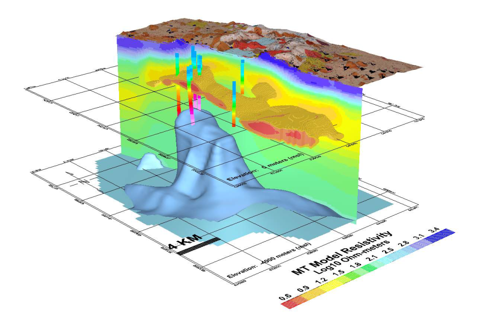
Processing and integrated interpretation performed by Zonge, of the MT results from more than 100 stations — with gravity data and drill-hole lithology — revealed valuable information about geologic structure and the volcanic development that significantly changed the understanding of which areas have higher potential for hosting hydrothermal systems.
On the flanks of the volcano, imaged MT data consistently showed three principal geoelectrical units. And among other findings, gravity data showed the subsurface volcano to be different from the observable topographic edifice.
more on MT method and depth of investigation
electrical resistivity contrasts at depths of several kilometers, a depth accessible to MT but not to other electrical or electromagnetic methods. MT is a passive method that uses naturally-occurring ionospheric current sheets and lightning storms as energy sources.
The MT method combines measurements of the earth’s electric field and magnetic field
over a wide band of frequencies. Information about the earth’s electrical resistivity for a particular frequency can be obtained from a simple ratio of orthogonal electric and magnetic components, for example |Ey/Hx|.
The depth of investigation is inversely related
to the square root of frequency such that
and high frequencies correspond to shallow samples. At Newberry, MT soundings sampled frequencies from 8200 Hz to 0.002 Hz. Given the rock resistivities encountered, this implies investigation depths from about 100 meters to more than 25 kilometers.
MT surveys are typically employed for the investigation of deep structures. In this case, however, integrating data from multiple surveys created a high density of recording stations that revealed some small-scale shallow features. Once data from the two MT data sets were combined, MT data contributed to shallow interpretation as well.
more on geophysics for geothermal exploration >>>