Frequency-Domain EM Induction

EM methods
In geophysics, the terms “Frequency-domain EM (FDEM)” and “EM induction” refer to geophysical investigation methods based on the principles of induction as defined by Faraday’s Law. As such, the EM induction umbrella covers all methods that involve measuring voltages induced in the earth when exposed to a varying magnetic field, either time- or frequency-domain.
EM methods are widely used for mapping lateral transitions in soil type, delineating leachate plumes, mapping discontinuities in aquitards, and detecting geologic features indicative of sand and gravel deposits.
EM Induction surveys
In the sub-specialty of shallow-surface, environmental geophysics, “FDEM” and “EM Induction” have a more narrow meaning — the terms are commonly used to refer to a specific type of survey for determining terrain conductivity (a bulk conductivity measurement) using low-induction-number, handheld instruments.
Zonge uses Geonics brand terrain-conductivity instruments for these shallow-surface surveys when applicable. Other equipment is recommended when greater accuracy at depth is required.
Shallow-surface EM Induction surveys…
- are conducted using portable equipment operated by a single person at walking speeds
- do not require any surface disturbance or direct contact with the ground
- can be conducted without exposure to buried toxic chemicals
- are a rapid, fairly inexpensive way to locate metallic objects
How it works
Electrical currents are induced into subsurface conductors by an operator-held transmitter loop that radiates an electromagnetic field. As the EM energy encounters different subsurface materials, eddy currents are induced creating secondary EM fields. This secondary field is recorded at the surface by a receiver loop. more
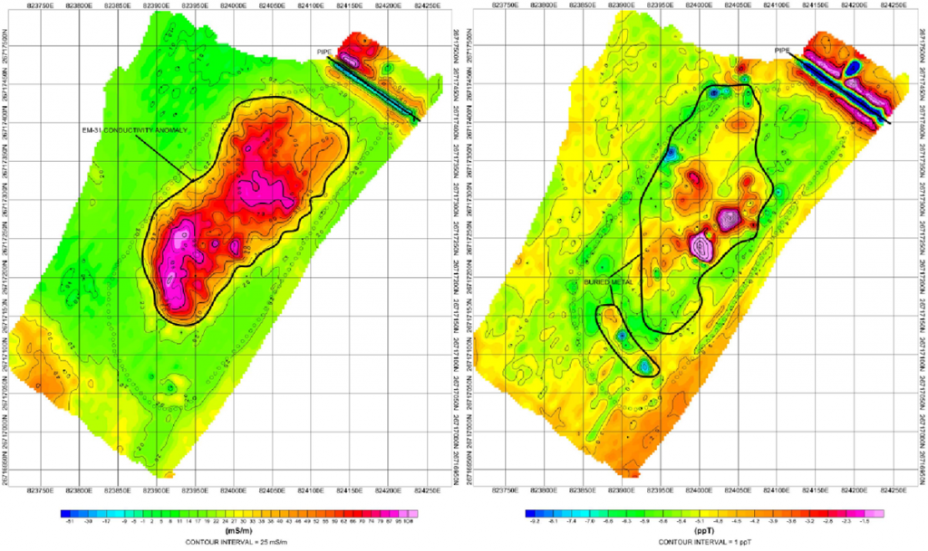
A data logger measures the component of the secondary field that is in-phase with the transmitted EM energy, plus that which is 90-degrees out-of-phase (the quadrature component). Typically, the in-phase component is strongly affected by the presence of buried metallic objects, while the quadrature component is directly related to terrain conductivity.
The terrain conductivity is determined by comparing the strength of the quadrature-phase component of the secondary field to the strength of the primary field. This apparent conductivity value represents a weighted average of the subsurface conductivity from the ground surface to the depth of exploration.
Depth of exploration
The depth of exploration depends on the separation between the transmitter loop and the receiver loop, as well as their orientation (horizontal or vertical axis). Using the various loop configurations possible with common Geonics equipment, the investigated depth ranges from about 8 feet to 175 feet below ground surface.
Deliverables
Typical deliverables include plan maps of project location and interfering cultural structures, color-contour maps of metal and earth conductivity responses, and interpretation maps with cultural responses and subsurface responses clearly separated.

