


Example Projects
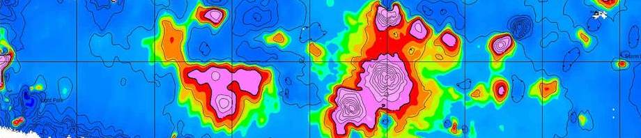
Reinterpretation, modern modeling of old with new data identifies new drill targets in the Round Top porphyry system
Western Alaska Copper & Gold partnered with Zonge International to revisit 1981-84 geophysics of the Round Top Cu-Mo-Ag porphyry system using modern modeling techniques. With integrated 3D imaging of the geophysics, geology and geochemistry, plus new lines of resistivity data, new zones of interest were identified with five follow-up and step-off targets. more
Integrated interpretation of MT, gravity, and drill-hole data reveal hydrothermal potential
Zonge International conducted two gravity surveys in the area of the Newberry Volcano for geothermal developer Davenport Newberry and collected further magnetotelluric (MT) data. Zonge processing and interpretation of the MT results from more than 100 stations, integrated with gravity data and drill hole lithology, revealed geologic structure and volcanic development information that significantly changed the understanding of which areas have higher potential for hosting hydrothermal systems. more
Detecting structural components, seepage zones guides remediation of Texas dam and spillway
Zonge contributed interpreted geophysical data to a comprehensive geotechnical review of Eagle Mountain Dam and Spillway Levee, two earthen structures north of Lake Worth, Texas maintained by the Tarrant Regional Water District. A combination of methods were used for determining, among other target information, depth below the dam crest and actual position and limits of known sheet-piling to guide remediation drilling activities. more
Geophysical studies serve both economic and environmental goals for long-term copper leaching operation
Zonge CSAMT surveys have been decisive in determining an efficient recovery-well system and in monitoring the in situ field at the San Manuel mine in southeastern Arizona where copper recovery is achieved through in situ leaching. Providing government entities with geophysical results to support monitoring-well data and hydrological models has been important in meeting regulatory requirements and was particularly useful for the environmental firm contracted to prepare the Aquifer Protection Permit for the state. more
Mapping pathways for DNAPL migration saves drilling costs
Drilling confirmed results of a Zonge IP survey determining the likely contaminant accumulation areas below a capped landfill. Preliminary results were available in the field, permitting the geophysics team, client, and state regulator to confer and make on-the-spot decisions. This led to the determination that fewer borings and wells were required to test a “worst-case” scenario, saving thousands in potential drilling costs. more
Resistivity data guides siting of groundwater well
CSAMT data show the regional geologic trend responsible for two radically different drilling results between monitoring wells. more
First-ever 3D seismic data of a breccia pipe reveals well-known Arizona Rose Breccia Pipe narrows at depth of uranium zone of interest
Conducted for the mineral-rights owner of a property with known uranium deposits where the Rose Breccia Pipe intersects the Hermit Shale Formation, this inventive survey revealed startling and important results for potential development. more
Man-portable DGM collection averages more than three acres per day
Zonge designed and built a man-portable, 2×1-meter platform — incorporating a transmitter loop and three, independent receiver loops — to identify targets of interest in a Digital Geophysical Mapping assignment at Fort Wingate Army Depot, New Mexico. The custom platform allowed acquisition of data over varied terrain while averaging more than three acres per day. more
Custom magnetometer array built to meet UXO detection requirements
With the requirement to detect and locate only ferrous metal targets, Zonge built a special-purpose, eight-sensor magnetometer array for use with a tow vehicle to collect more than 200 acres of geophysical data in the Hastings Multi-purpose Training Range at Fort Benning, Georgia. Deliverables included 425 final maps of one-acre parcels. more